The Rai Swingbridge crosses the deep aquamarine blue of Rai River as part of a beautiful gentle walking circuit through totara forest (one of several walks in the area). This sturdy structure has far less swing and sway than its cousin over Buller Gorge.
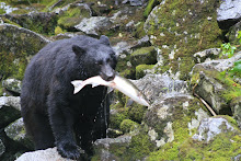
It is all part of Pelorus Sound Scenic Reserve, a wonderfully preserved pocket of historic forest encrusting the far sinewy reaches of Pelorus Sound. It is a perfect stopping point between Queen Charlotte Sound and Nelson to stretch the legs and enjoy the uplifting New Zealand outdoors. Fat lumbering brown trout can be spotted sluggishly swimming upstream through the crystalline waters.
Showing posts with label hiking. Show all posts
Showing posts with label hiking. Show all posts
Sunday, April 15, 2012
Pelorus Sound Scenic Reserve (New Zealand)

Saturday, March 24, 2012
Swimming Hikes on Kauai (Hawaii, USA)

guest post by Great Vacation Retreats
The island of Kauai, of one of the main islands in the Hawaiian archipelago, is noted for its jugged mountains, palm fringed beaches, and beautiful tropical scenery. For those that enjoy outdoor exploration, Kauai offers many exceptional hikes. An especially enjoyable and unique activity is combining hiking and swimming. There's nothing quite like cooling off with a swim in the ocean after the exertion of a strenuous hike. Below, we outline four hikes on Kauai that begin and end at the ocean. The first hike is an easy 1.5 mile round trip that starts and ends at Moloaa Bay on Kauai's northeast coast. Moloaa Bay is a beautiful crescent shaped beach, made famous when it was used for the first episode of the TV series Gilligan's Island. The trail begins at the north end of the beach and makes its way along the coast, eventually coming to a dead end at private property. The ocean views along the trail are soothing, and in the winter months you may even spot migrating Humpback whales. You can end your hike with swimming or snorkeling at the bay. For a convenient picnic lunch, the Moloaa Sunrise fruit stand nearby sells all sorts of healthy and tasty treats, from smoothies to sandwiches.
 One of the most famous hikes in Hawaii is the Kalalau Trail along Kauai's rugged Napali coast. The Kalalau Trail is 11 miles long and suitable for experienced hikers who are prepared to spend a night camping in the Kalalau valley. For a challenging day hike one can hike the first two miles of the trail to Hanakapi'ai Beach. Resist the urge to swim at this remote beach as it's one of the most dangerous on the island with strong currents at all times. At this point you can turn back, or hike inland for 2 miles to the 300 foot high Hanakapi'ai Falls. Including the falls this makes for an 8 mile hike that takes around seven hours. It's important to prepare for this hike with hiking gear and plenty of water and snacks. The trail changes elevation frequently and can be very slippery when it rains. The Kalalau Trail starts at the end of the highway on Kauai's north shore at Ke'e beach. This beach has excellent swimming and snorkeling, especially in the summer months when the ocean is calmer.
In the town of Kapaa on the eastern coast of Kauai is the Kapaa Bike Path, a four mile long ocean side paved path. This hike is ideal for those that don't like inclines, or need a smooth walking surface. The path passes by Kealia Beach, a life guarded beach with swimming, surfing, and boogie boarding. The beach actually makes for a good starting and ending point. Walking north from Kealia takes you through the most scenic section of the path and to another beach called Donkey Beach. This segment is approximately three miles round trip. In Poipu on the southern coast of Kauai is the Mahaulepu Coastal Trail (also see top photo). The trail starts at Shipwreck Beach in front the Grand Hyatt hotel and continues along undeveloped coastline for about three miles, passing remote Mahaulepu Beach two miles into the hike. It's not uncommon to see an endangered monk seal napping on the sand. The solitude and beautiful ocean views make this one of the best hikes on the island. Although there are no inclines the hike is still fairly strenuous as parts of it are over sand and there are few trees to provide shade from the hot Hawaii sun.
This article (and photography) was provided by Great Vacation Retreats, a Kauai vacation rental agency. Great Vacation Retreats manages a number of rental properties including rentals at Puu Poa, a luxury condominium complex in Princeville.
Wednesday, September 28, 2011
Climbing and Diving in Sabah (Malaysia)

guest post by Samantha Deavin Climbing and diving are two of the main attractions of Sabah – the Malaysian state located on the northern point of the island of Borneo. The famous Mount Kinabulu is a magnet for adventurers and climbing enthusiasts while the stunning underwater ecosystem of the Sipadan reef lures avid divers.
For those who have walked the well trodden tourist path of South East Asia, Sabah presents a refreshing alternative and a chance to get off the proverbial ‘beaten track’. Borneo’s north eastern area is rich in treasures, so if you have a bit of time up your sleeve you won’t want to limit yourself to Mount Kinabalu or Sabah’s diving Mecca. But for first time visitors or those with a limited time budget, Mount Kinabalu and the Sipadan reef should be top of the list.
There are a number of cheap flights available to Malaysia and nearby areas that will put you in easy reach of both Mount Kinabalu and the tropical island of Sipadan – two of Sabah’s main attractions.
Mount Kinabalu Mount Kinabalu is the tallest climbable mountain in South East Asia, rising 4,095 m above sea level. Many tourists flock to Sabah’s capital city Kota Kinabalu before heading into Kinabalu National Park to attempt the eight kilometre climb to the peak. Generally the climb takes two days, and no climbing experience is necessary. On the mountain’s tourist trail, climbers spend one night at the huts in the vicinity of Laban Rata before reaching the summit at sunrise for spectacular and breathtaking views over the Crocker Mountain Range. On the walk, climbers will make their way through five different vegetation zones.
Climbing Mount Kinabalu is a rewarding experience. Not only will you meet great people along the way and enjoy majestic and magical views, but you’ll experience a very special place to the local people in Sabah, Malaysia, who believe that the souls of their ancestors have gone up the mountain.
Scuba Diving Diving is the other premier attraction of Sabah with its waters home to fantastic marine diversity. There are a range of scuba diving landscapes to explore, from coral reefs to wreck driving to stunning drop offs. The most popular and coveted dive spots are around the islands of Sipadan, where the reef drops down spectacularly and huge schools of barracudas and mackerels are seen on nearly every dive, as well as turtles and large sharks.
There are various dive sites around the island – all of them different, but offering an amazing array of underwater attractions. The Sipadan reef is a world class dive spot – not to mention a beautiful one!
Once you get to Sabah, you’ll want more time to explore all that this rich and diverse region has to offer.
Have you ever been to Sabah? What are your tips for climbing and diving in this area?
Photo Credits: sunrise, turtle, kota kinabalu, fish,
Monday, May 16, 2011
Tea and Trekking (Cameron Highlands, Malaysia)

 The Cameron Highlands are Malaysia’s relief valve from the oppressive equatorial heat and humidity of the capital and the beaches. Gloriously cool and refreshing, the Cameron Highlands are gently rolling, misty hills, dramatic peaks and fertile soils filled with tea plantations, lush jungle trails, fruit and vegetable farms and weekend retreats.
Being the finest in natural air-conditioning, the Cameron Highlands are ridiculously busy and touristy on the weekends so two strong suggestions are to come during the week and to avoid the glitzy and clichéd tours. Apart from the restful escape from the heat, the highlight of the area is the tea plantations (I’d recommend Boh Tea Estate). With sweeping torrents of emerald green tea plants smothering the hills all the way to the horizon, the plantations are a hive of activity. Strange aerial lawnmowers clip the leaves from the tops of the plants, gathering the valuable crop into a trailing sack. Others (mainly Indian and Nepalese immigrants) beaver away like manic barbers clipping the sides of the tea plants for further leaves. This process is repeated on each plant every couple of weeks giving a hedge-like appearance to the plantation.
The leaves are wilted (brings out the flavour), tumbled in trays, left for a time to oxidise, rolled and dried to produce the familiar leaves that make for the fine cups that many of us enjoy each day. Indeed, nothing is more relaxing than sinking into a comfortable chair, gazing over the highlands and sipping on a freshly brewed cup of tea.
Avoid the tours that ship visitors to an indigenous village (for a demonstration of blow-pipe hunting), a temple or two and a variety of honey, strawberry, butterfly, cactus and flower farms (but completely and utterly fail to capture the spirit and nature of the Malaysian highlands).  Instead, grab a map (the trail markings aren’t so good) from the main town of Tanah Rata and a rain jacket and follow one of the numerous trails. One good path wanders through lush and refreshing forests for around an hour to one of the areas tumbling waterfalls, Robinson Falls (where the trail continues onto the Boh Tea Estate).
Finish the day with a dinner of delicious satays and Chinese steamboat where you cook a mixture of vegetables, meat and seafood into a thin steaming broth at your table.
The Cameron Highlands is one of Malaysia’s best sights with a quaintly English feel to it. Enjoy the refreshing cool temperatures, lush greenery, the country cottages and discover the mysteries of tea making before sipping a delightful brew overlooking the sweeping hills and lush jungle vistas.
Photo Credit: Robinson Falls
Thursday, March 17, 2011
Ambling around Chamonix (France)

guest post by Isabella Rose of MyDestinationInfo.com Home to the French Alps tallest peak, Chamonix taunts snow-sports enthusiasts with slopes just begging to be tarnished by the touch of skis. However, with the overshadowing call of the wily temptress, aka Mont Blanc, and the idyllic Chamonix weather, many have overlooked the effervescent town that sits at the base of her tumbling snowfall.
Unlike other French purpose-built ski resorts, naming no names of course (cough Courchevel cough), Chamonix is an authentic town whose vibrant streets buzz with the sounds of daily life. With historical sights and cultural attractions lining the town’s pedestrianized streets there are countless opportunities for ambling.
I feel I should take a short moment here to bask in the definition of ‘ambling’. Defined as ‘an unhurried or leisurely walk’, speed demons and adrenalin junkies who live to hurtle down mountains, jump out of airplanes and throw themselves of cliffs should really take note here. For my fellow ambling friends however, who similarly rejoice in the simple pleasure of a pleasant stroll, here are some of the best opportunities for ambling around in Chamonix.
Guided Heritage Tour Run by Chamonix’s local tourist office, a guided heritage walk around the town is an ambler’s dream. Beginning at Le Triangle de L’Amitié, home to the Mairie, Chamonix’s triumphant town hall, the tour continues on to explore Chamonix’s historic buildings and churches laced with the baroque and art deco style. On your way you will witness small pockets of hamlets and villages pervading the town, a testament to Chamonix’s diversity of life. With an abundance of cafes, restaurants and bars there is plenty of opportunity to refuel along the way. My ambling advice: check out the Chalet le Cerro, a quaint alpine chalet serving traditional French cuisine. The three-cheese fondue is worth the indulgence, just be warned your feet may feel a little heavier after this hearty feast!
Open Air Markets Chamonix’s open air markets thrive with the hustle and bustle of local trade, providing ample opportunity for ambling. Authentic Savoyard aromas float through the air tempting you with delicious French flavours. With home-grown produce and local dairy such as the Tomme and reblochon cheese, those who enjoy the finer things in life can bask in Chamonix’s rich culinary culture and the slower pace of European life. For those who prefer a seasonal market however, the Christmas Market Argentiere held at the local town hall is ideal for a winter’s stroll. Full of festive cheer, market stalls selling traditional decorations and wooden arts and crafts are offered up here for your leisurely perusal.
Chamonix Alpine Museum If ever there is a place where an ambler is truly at home it’s in a museum. Rich in visual history, Chamonix has several museum and gallery hot-spots. Tracing the history of the town’s origins, the Alpine Museum is a great place to start. From humble beginnings to a thriving ski resort proudly hosting the first Winter Olympics, the museum explores Chamonix’s rising success. With numerous prints, sketches and photographs to survey, art-amblers are bound to be busy for hours.
After a leisurely day of bumbling along Chamonix’s streets, you may find your legs a little shaky and your feet a little achy. Fear not! Hotels in Chamonix are a great place for expert-amblers to retire after a long day of exploration. From alpine lodges to catered chalets, swimming pools and Jacuzzi’s are on hand to provide a soothing soak at the end of the day.
For a more information on Chamonix peruse the pages of My Destination Chamonix, one of the best comprehensive guides on the area.
Photo Credits: reflection, flags, spice market
Wednesday, April 14, 2010
Ice Magic (Werfen, Austria)

 The Eisriesenwelt (World of the Ice Giant) is a wintry wonderland of naturally produced dazzling ice formations. Hidden in the Austrian Alps south of Salzburg, thawing ice drips into a labyrinthine cave and re-freezes into beautiful formations. Evocative names like the Ice Organ, Odin’s Hall and the Frozen Falls offers a glimpse of the remarkable ice patterns nature sculpts through the cave’s corridors.
 The journey to the Werfen ice caves provides part of the experience. A fifteen minute walk from the bus stop leads through alpine forests and glorious mountain panoramas, past the imposing Hohenwerfen Castle and to a small hut. From here, a short cable car ride climbs a vertical rock wall of 500 metres. From the top of the cable car, a steadily ascending fifteen minute walk along Pincer Path leads ominously to a small rounded dark archway punched into the mountain side.
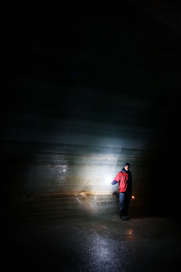
 The guide greets the small party handing out instructions and small Davy Lamps to help find your path through the chambers. Ice already paints the walls and crunches underfoot. Through the first room and the group is met by a huge 20 metre high sheet of ice extends across the cave. The guide lights small strips of magnesium which shoots a sharp shot of bright light illuminating the magic of the cave for a few seconds before the light expires and the dull glow of the lamps and guide’s torch offer a more chilly feeling.
 A narrow passage called Hymir’s Hall is named after the ice giant in the Norse sagas with the main formation being a huge overhanging presence called Hymir’s Castle. Carefully stepping between the castle and the Ice Chapel, the remarkable ice trees appear through the gloom. Sparkling on lighting of the magnesium strips, the trunks have tiny horizontal ice branches caused by the ever present cave winds that blow the water droplets into these patterns.
 With more Norse inspiration, Odin’s Hall has a ceiling sprinkled in ice crystals like the starriest of dark nights while the deep bluish-green Castle of the Gods glistens against the rust-red cave walls. Through further immense caverns, the gleaming Ice Palace is the point to return having travelled 800 metres into the cave. On the path out, the staggering Mork Glacier has a polished eight metre wall smoothed by the wind and with elegant blue and white stripes sprinkled with brown cave dust. Occasional releases of magnesium strips illuminate the wonderful caverns into a fairy wonderland.
Accessible ice caves are relatively rare requiring elevations between 1400 and 2000 metres above sea level and suitable winters and summers. Eisriesenwelt, at Werfen, is the world’s largest ice cave and is a dream-like travel wonder in the Austrian Alps, making for a rewarding half-day visit among the majestic alpine vistas.
Note: Photography is not permitted in the caves but I found some secretive shots taken by Tania Ho, PsychoScheiko and Johan Lindgren.
Friday, March 5, 2010
Walking the Andean Wilds (Cajas National Park , Ecuador)

 Less than an hour by bus from the seductive colonial city of Cuenca is the primeval travel wonder of Cajas National Park. Numerous paths criss-cross the majestic, but bleak Ecuadorean wilderness that has striking similarities to the west of Scotland. The routes are numbered but signage is extremely limited making hiking in this park without a detailed map or economical local guide difficult.
I’d never planned to walk in Cajas but Cuenca’s Foundation Day meant everything in this colonial masterpiece had cerrado signs dangling from their doors and most buses weren’t running. Teaming up with a lively French woman, Bernadette and finding a guide, Juan, we set out for a day of hiking.
One excellent hike starts at Tres Cruces. With staggering views over the park from a height of over 4,000 metres above sea level, the geological history of the park becomes clearer. From a misty Andean backdrop, glaciers have gouged a primeval landscape of austere green-tinged valleys pockmarked with a glittering array of small sparkling lakes, small gnarled forests and dark volcanic rocky outcrops.
The lakes are called “box lakes” that being one explanation for where the park obtained its name, cajas being Spanish for boxes. Another variation describes that caxas is Quechuan (the local Indian language and that spoken by the Incas) for cold.  Many of the 200 plus swampy lakes have evocative names though I couldn’t see any resemblance between the shimmering Lake Toreadora and the famed image of a Spanish bullfighter.
Here, the hill-line or continental divide is significant as all water that falls on the west of the mountains runs into the Pacific Ocean and all water that falls east of the hills journeys over 1000 miles via the Amazon basin before emptying into the Atlantic. This harsh environment supports a surprising amount of life. Overhead, a rare condor patrols his dominion cruising the currents of rarefied air that lift off the jagged peaks. Small colourful wildflowers and plants litter the pathways. Among the hardy grasses and rocky ground, Indian Paintbrush dots the landscape in scarlets spots while the chuquiragua is highlighted by orange flowers, both thriving in this harsh climate.
  Small forests of twisted polylepis and quinua trees sit high above the general tree-line and create a diversion from the treeless higher valleys. Like entering middle earth and presenting a maze like an obstacle course, these knotted trees twist and turn blocking the path and catching daypacks at every opportunity. The branches of the polylepis trees have strange reddish multi-layer papery bark that flakes off in sheets and are unique to the Andes. Small birds dart easily between the foliage picking at the leaves and insects.
 The day’s walking can be broken with a superb lunch of steamed trout from the park in a well-priced restaurant called Dos Chorreras, perched on a small lake and with a sweeping panorama of the park.
Despite being so close and so easily accessed from Cuenca, Cajas National Park offers wonderful hiking and a tremendous sense of solitude and wilderness. With breathtaking Andean backdrops, walking the unforgiving landscape in ever-changing weather and high altitudes gives a sense of elation and pride when settling back into colonial Cuenca. And to think, if it wasn’t for a public holiday, I’d have missed this Ecuadorian travel wonder.

Saturday, November 21, 2009
A Little Switzerland in Luxembourg

 The tiny travel wonder of Luxembourg, precariously sandwiched between France and Germany at a European crossroads has a woven web of hiking paths that crisscross the country. While the city features excellent historic walks such as the Wenzel Walk, the northern part of Luxembourg offers a tremendous array of walking and hiking options. With maps available from tourist offices and clear signposts with blue triangles marking the paths, hiking is one of Luxembourg’s most popular leisurely pursuits (after all, one-third of the country is forested). And there is no better place to walk than the grandly named Little Switzerland. While there is nothing alpine about this lowland region, the dramatic landscape gives some credibility to its moniker.
 Start from the country’s oldest town of Echternach with its sprawling abbey credited to St Willibrord (a wily Yorkshireman who the locals believed cured epilepsy in the seventh century). With little thought over a strong steaming coffee, I selected E1 (see map), a suitable sounding walk of twelve kilometres. After a short but strenuous climb, a nice viewpoint (Troosknäppchen) offers fine vistas of the abbey and town.
 The path follows the Müllerthal Trail (the miller’s path named from the numerous watermills that once existed on the river) quickly leading to densely wooded forests, lush verdant valleys and spectacular rock formations. Left over from the Ice Age, roughly hewn rock steps and ladders weave a narrow, twisting path between towering 20 metre high rock walls at times only wide enough for a single file of walkers.
 This ancient landscape generates its own steamy microclimate of high humidity producing vegetation unique to Europe with moss coating everything in a carpet of green and ferns sprouting from small rocky crevices.
The trail leads through the evocatively named Wolfsschlucht (the wolves’ lair - top photo) that apparently sheltered wolves in times past. Continuing along a tiny brook, through the Labyrinth and past the giant single rock of Perekop, the trail leads to Hohllay. This is an old cave where traces remain where millstones were cut. Regular performances still run at the nearby amphitheatre, a wonderful natural location for plays, theatre and music. Sharing lunch with a couple of hikers, climbers clambered up the sheer rock walls, the occasional yelp of a slipping climber being caught by his ropes breaking the peaceful forest ambiance.
 Turning back along a small creek with tiny waterfalls, the path toured via Zig-zag Gorge (photo below right) and an atmospheric cavern called Räuberhöhle (thief’s hideout - photo left) before tracking the Sûre River back to Echternach.
 It seems an accident of history that this tiny country exists as an independent country with its history of battles and wars. Indeed, the castles that litter nearly every rocky outcrop, gorge and small hill is a strong reminder of how many battles have been fought over the years for this scenic centre of Europe. It is a gift as the feisty and proud population of the self-promoted “Europe’s smallest big country” offer superb trekking through well-preserved forests broken only by the occasional muffled greeting of moien in the strange sounding German-like dialect.
Other Benelux Posts
1000 Years in 100 Minutes (Luxembourg City)
A City of More than Sex and Drugs? (Amsterdam)
Belgian Pride
Drinks Around the World: Chimay Beer
Note
More details available from the Müllerthal Trail website.
Wednesday, November 18, 2009
1000 Years in 100 Minutes (Luxembourg)

Since 963 when Count Siegfried first built a castle on a rocky outcrop overlooking a sharp bend in the Alzette River, various European powers have battled for control of the tiny state of Luxembourg. At times, the Burgundians, Spanish, French, Austrians, Prussians and Germans have all held sway over this scenic nation wedged between France and Germany. Despite a tumultuous history of almost permanent siege, this pint-sized nation has survived to modern times and now is one of richest per capita countries in the world. Luxembourg boasts excellent walks including the city-based Wenzel Walk and a superb nature walk in an area called Little Switzerland. The delightful and well-signposted Wenzel walk (either guided or self-guided with a pamphlet) in the main city of Luxembourg and named after a 14th century duke captures elements of this history and culture, leading past ramparts, fortresses, tunnels, towers, bridges and walls, intermixed with bustling streets and panoramic views. The narrow valley gorges plunge sharply and deep from the rocky plateaus of the city, connected and spanned by various bridges and viaducts, ingeniously protecting and guarding this challenging terrain.
 The walk starts at Bock Promontory and the scant remains of Count Siegfried’s Luxembourg Castle that started this rich history. The view from this point includes the Alzette river slicing the ancient district of Grund into two. Jacob’s Tower includes an audio-visual display describing the history. Underneath the Bock are a warren of tens of kilometres of damp tunnels (Bock Casemates) that allowed soldiers access to different parts of the city without surfacing and held provisions in past times. The various invading forces extended and added to these fortifications throughout the years and were utilised as recently as World War 2 as bomb shelters. Accessible for less than two Euros, they make for an eerie passage with a combination of small natural openings, weak electric lights, twisting staircases and occasional dead ends. These remarkable fortifications earned Luxembourg the title of Gibraltar of the North and have earned UNESCO heritage listing.
Some defensive openings to allow for guns or cannons offer stunning vistas of the Luxembourg countryside, the picturesque Old Town or river valleys. The walk leads via the Corniche lined with stately pastel-coloured historic houses, through old protective city gates, over a medieval footbridge to the impressive Wenzel Walls and its moat. These fortifications were part of a three-ringed system of walls guarding the prized higher parts of the city and major crossing of the river.
The walk finishes near the city’s oldest parish Church of St Ulric with a walk along the green waters of the Alzette and the remains of an old lock system that could be used to dam the rivers as an extra obstacle for invading forces.
Descriptively promoted as 1000 Years in 100 Minutes, the Wenzel Walk, in under two hours, unveils part of Luxembourg’s historic battles for domination and the ingenious defensive fortifications built to protect this strategic historic city.
Note
The tourist office has an excellent self-guiding brochure.
Map (without red lines): © Service des Sites et Monuments Nationaux / Luxembourg City Tourist Office
Tuesday, May 19, 2009
The Waterfall Hidden in a Mountain (Trümmelbach Falls, Switzerland)

 If one location can summarise the travel wonder of the European Alps and Switzerland, it is Interlaken and the Bernese Oberland. Sandwiched between two sparkling azure lakes, Interlaken stares at the towering giants of Eiger, Mönch and Jungfrau and the snaking icy river, Aletsch Glacier, which is Europe’s longest. Beautiful days in nature can be spent wandering between the traditional mountain villages and through the scenic verdant valleys.
 One excellent journey starts by taking a train from Interlaken to Lauterbrunnen and walking around five kilometers along a well sign-posted route to Trümmelbach Falls. The crisp fresh air, the amphitheatre of mountains, the tranquil setting and the glorious blooming wildflowers all brighten the steps and quicken the stride. Glorious waterfalls tumble down niches in the rock walls, none more impressive than the 300 metres Staubbach Falls that seemingly tumbles into Lauterbrunnen itself and gives it its name of Valley of Loud Waters.
 In under an hour, the path crosses a small bridge with a raging torrent of water (turns out to be the bottom of Trümmelbach Falls) and an elevator which shoots to the top of the falls. Step out and meet a wall of deafening noise. Trümmelbach Falls gushes and carves its way down a tortured path of twists and turns having gouged its tumultuous journey over many thousands of years. Tiny lookouts onto the gushing water litter the path, the freezing spray stinging the face as small droplets strike unguarded skin. Subtle lighting along the narrow damp pathway and natural shafts of light from crevices in the rock sets an eerie scene with a background of the constant ear-piercing drumming of columns of milky glacial foaming water pounding into rock. Indeed, this waterfall is far more heard than seen.
A tri-lingual sign at the bottom summarises the crescendo of sound in numbers: "Ten glacier-waterfalls inside the mountain made accessible by tunnel-lift and illuminated. The Trümmelbach alone drains the mighty glacier defiles of Eiger (3970m), Monk (4099m) and Jungfrau (4158m) and carries 20,200 tons of boulder detritus per year. Its drainage area is 24 sq km, half of it covered by snow and glaciers. Up to 20,000 litres of water per second. The only glacier-waterfalls in Europe inside the mountain and still accessible."
It is certainly worth a short journey through this mountain hideaway waterfall as a break from the visual feast of stupendous Swiss mountain and verdant valley beauty. The intensity of the sound from the huge volumes of water escaping the narrow rocky passage test the hearing but leave an incredible impression of the outrageous power of nature and time.
Photo Source: map, mountains

Subscribe to:
Posts (Atom)